stud
bud
Sign up
Log in
Home
Library
Explore
SAT
More
Climate Flashcards | StudBud
Explore
/
Climate
Climate
50 terms
·
StudBud Administration
·
3,051 plays
Regents Earth Science #climate #regentsearthscience
Flashcards
50 cards
F
Practice quiz
P
Host live
L
Questions
50
Answers
1
Why is Antarctica’s cold climate responsible for its very low amount of yearly precipitation
Cold air holds very little water vapor
air is sinking, therefore, clouds seldom form
it is a low pressure area
Very little evaporation takes place in Antarctica
2
The ocean currents are primarily driven by
Conduction
Coriolis
Ms. Susinno's Kia Forte
The planetary winds
3
During an El Nino event, the Eastward-blowing winds get weaker
false
true
4
Why does heavy snow fall in the Tug-Hill Plateau region?
It is a lower elevation
adiabatic cooling
It is a higher elevation
orographic effect
5
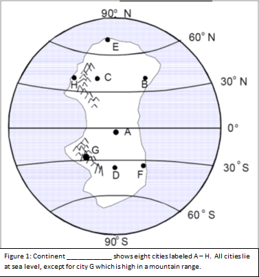
Describe the climate of City A, and the primary factor affecting it.
Great temp range, dry because it is landlocked
Warmer&drier because it is on the leeward side of a mountain
Warm and humid because it is on the equator
Moderate temp and humid because it is coastal
6
Describe the climate of City F
Dry and cold
Moderated Temperatures
Warmer summers and cooler winters
Humid
7
A high air-pressure, dry-climate belt is located at which Earth latitude?
15° N
60° N
0°
30° N
8
During an El Nino year winter in NY will generally be
warmer and drier
cooler and drier
cooler and humid
not affected
9
Which city would have the driest climate?
C
D
A
B
10
The East Australian Current is warm.
false
true
11
Identify the 2 wind belts that drive the currents in the North pacific Gyre
West
SouthEast
NorthEast
SouthWest
12
Which factor is most influential in determining the humidity and average temps of a location
orographic effect
nearness to a large body of water
latitude
nearness to mountain chain
13
City
A
has very little variation in temperature during the year because city
A
is located
near the coast
At the North Pole
in the Southern Hemisphere
Near the equator
14
Surface ocean currents located at 40º south , 90º west generally flow toward the
Southeast
Southwest
West
Northeast
15
Which wind belt has the greatest effect on the climate of New York State?
prevailing southwesterlies
northeast trades
prevailing northwesterlies
southeast trades
16
Which location has the warmest climate
D
C
B
A
17
During which season does city
B
experience the month with the highest average precipitation?
summer
spring
winter
fall
18
How does the climate of Seattle compare with the climate of Spokane?
Seattle is warmer
Seattle is cooler
Spokane is less humid
Spokane is warmer
19
Earth's warm interglacial intervals are due primarily to
Milankovitch Cycles
changes in Earth's period of rotation
increases in elevation of North America
changes in Earth's orbit and tilt
20
A shift in the trade winds cause sea levels during El Nino years to:
increase at both Australia and South America
decrease at Australia and increase at South America
increase at Australia and decrease at South America
decrease at Australia and South America
21
El Nino is often associated with wet winters along the northwestern coast of South America
false
true
22
The primary factor controlling these climate zones is
longitude
Nearness to bodies of water
latitude
elevation
23
Corals are found in warm, shallow seas.There are coral fossils in Alaska.This suggests that
Alaska was located at a different latitude
Alaska once had a warm climate
Alaska had a different angle of insolation
Alaska has since moved
24
What is the air mass from Canada that produces lake-effect snow in New York State?
cP
cT
mT
mP
25
Banning CFCs in certain products helped to slow the size of the hole in the ozone layer
true
false
26
Compared to inland locations, climate of locations influenced by a nearby ocean have
Hotter summers, colder winters large range in temp
similar temperatures
cooler winters cooler summers little range in temp
cooler summers, warmer winters, less range in temp
27
The hole in the ozone layer is from CFCs released from airplanes and aerosol cans
false
true
28
Explain relationship between water temp and land temp for lake effect snow to happen
Water temp is cooler than land
Water temp is equal to land
There is no relationship
Water temp is warmer than land
29
See question below:
1
3
2
4
30
Which single factor has the greatest effect on the climate of an area on the Earth's surface?
the degrees of longitude
the distance from the Equator
the extent of vegetative cover
the month of the year
31
Describe the climate at City C
Cooler and drier-leeward side of mountain
Cooler and more humid- windward side of a mountain
warmer and drier-windward side of a mountain
Warmer and drier- it is on the leeward side of a mountain
32
Describe sea surface temp and Pacific Trade winds along the South American Coast During El Nino
SST is cooler, Pacific Trades are from the West
SST are warmer and Pacific Trades are from the East
SST are warmer and Pacific Trades are from the West
SST and Pacific Trades remain the same
33
Name the current by city D
West Greenland
Labrador
Norwegian
North Atlantic
34
It can be concluded that city
C
is located in the Southern Hemisphere because city
C
has
small amounts of precipitation throughout the year
large amounts of precipitation throughout the year
its warmest temperatures in July and August
its warmest temperatures in January and February
35
According to the map, locations in the mid-latitudes have average monthly temperatures between:
Between 10°C and 18°C
Between 30°C and 40°C
Between 20°C and 60°C
They are relatively constant at about 70°F
36
Heavy monsoon rains occur in India during
January, when winds blow toward high pressure
July, when winds blow from the ocean
January, when winds blow from the land
July, when winds blow toward high pressure
37
Ozone gas helps to protect life on the Earth due to its ability to absorb
visible light
gamma radiation
ultraviolet radiation
radio waves
38
How do monsoon winds affect India's weather in summer and winter?
Winter is warmer and less humid than summer
Winter is cooler and more humid than summer
Summer is warmer and more humid than winter
Summer is cooler and less humid than winter
39
Compared to the climate of location A, the climate of location B is
warmer and wetter
cooler and wetter
cooler and drier
warmer and drier
40
Very little water will infiltrate the soil around city D because the region usually has
permeable soil
nearly flat surfaces
a small amount of runoff
a frozen surface
41
The hole in the ozone layer is the cause of global warming.
false
true
42
Which type of radiation from Earth is the long-wave radiation absorbed by greenhouse gases?
ultraviolet
visible light
radio waves
infrared
43
Landfills give off greenhouse gases
true
false
44
How can there be snow on the equator?
High elevation
Elsa lives there
There are glaciers on top of mountains
If the location is very far inland
45
Surface ocean currents curve to the right in the Northern Hemisphere because
the Moon spins on its axis
the Moon travels in an orbit around Earth
Earth travels in an orbit around the Sun
Earth spins on its axis
46
If a place has a high potential evapotranspiration and little actual evapotranspiration it is
cold and humid
hot and arid
hot and humid
cold and arid
47
Describe the temperature at city G
Cooler because it is a high latitude
cooler because it is on the windward side of a mountain
Cooler because there is less pressure
Cooler because it is at the top of a mountain
48
Which statement best describes the monsoon winds during the rainy season in India?
Warm, moist air flows from India to the Indian Ocean.
Cold, dry air flows from the Indian Ocean to India.
Cold, dry air flows from India to the Indian Ocean.
Warm, moist air flows from the Indian Ocean to India.
49
Why are locations East of Lake Ontario more likely to have lake effect snow?
They are on the windwardside
The tradewinds are blowing from East to West
They are on the leeward side plateaus
The prevailing southwesterlies carry moisture over the lake
50
The primary cause of surface ocean currents is
atmospheric transparency
Planetary winds
Evaporation of water
ocean floor earthquakes