stud
bud
Sign up
Log in
Home
Library
Explore
SAT
More
How well do you know Australia? Year 9 Geography Flashcards | StudBud
Explore
/
How well do you know Australia? Year 9 Geography
How well do you know Australia? Year 9 Geography
38 terms
·
StudBud Administration
·
185 plays
Imported from external platform
Flashcards
38 cards
F
Practice quiz
P
Host live
L
Questions
38
Answers
1
This image of Lake Eyre would have been produced by:
Satellite
oblique aerial photography
using a big tripod
Mobile phone
2
Scale on a map is used to show..?
differences in time zones
climate zones
the relationship between the map and the real world
distances in kilometres
3
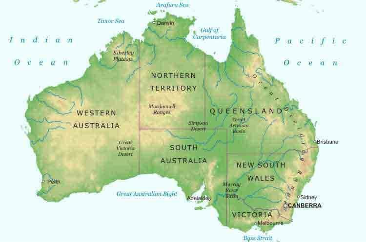
Australia's largest state by area is?
SA
QLD
WA
NSW
4
High pressure systems move in which direction?
anti-clockwise
horizontally
diagonally
clockwise
5
These animals are an example of:
Mammals
Mammoths
Monotremes
Marsupials
6
One of Australia's main landform regions is:
The Central Lowlands
The Western Plains
The Great Australian Bight
The Southern Highlands
7
The lines on a weather map show..
air pressure
temperature
cyclones
rainfall
8
Two of Australia's nearest neighbours are?
Noumea & Sri Lanka
Papua New Guinea & India
Japan & Singapore
New Zealand & Indonesia
9
This picture of the Bungle Bungles shows an example of?
erosion and weathering
glacial activity
volcanic activity
fold mountains
10
The Ocean to the east of Australia is the:
Atlantic
Pacific
Indian
Southern
11
To describe Australia's location you would say it is in the:
Northern and Eastern Hemishpheres
Eastern and Southern Hemispheres
Western and Southern Hemispheres
Southern and Western Hemispheres
12
Geographically, economically and politically, Australia's most important links are with:
Bali
The USA
The Asia-Pacific region
Europe
13
The largest river in Australia is
The Richmond
The Murray-Darling
The Macleay
The Clarence
14
Of all the continents, Australia is regarded as the:
wettest
largest
highest
flattest
15
Latitudes in Australia all feature which letter?
S
N
E
W
16
The easternmost point in Australia is?
Cape York
Steep Point
Wilson's Promontory
Byron Bay
17
This letter indicates all of Australia's latitudes are in which hemisphere?
Southern
Northern
Western
Eastern
18
Australia sits on which tectonic plate?
South American
Indo-Australian
Antarctic
Eurasian
19
Australia is bigger in area than this country:
India
Russia
China
Brazil
20
The lowest point in Australia is?
Tasmania
the Great Australian Bight
Lake Eyre
Cape York
21
The line of latitude running through Rockhampton QLD is?
The Tropic of Cancer
The Tropic of Capricorn
The International Date Line
The Equator
22
another name for a weather map is
maritime chart
synoptic chart
choropleth map
topographic map
23
The distance south to north at the furthest point in Australia is?
3138 kms
4500kms
19700 kms
2228 metres
24
Evidence for Aboriginal occupation of the land comes from:
Lake Eyre
Lake Mungo
Mt Kosciusko
Mount Isa
25
The current population of Australia is approximately...
150 million
3 million
24 million
88 million
26
Aboriginal people were able to migrate to this continent because:
there was an ice age
gondwana was still one landmass
sea levels were higher
sea levels were lower
27
This is an image of..
Adelaide
Brisbane
Melbourne
Sydney
28
Australia is located between these oceans.
Southern and Indian
Indian and Pacific
Pacific and Atlantic
Tasman and Coral
29
The Capital of NSW is?
Brisbane
Canberra
Sydney
Newcastle
30
It is believed that Aboriginal people have occupied Australia for at least:
40000 years
40 years
400 years
4000 years
31
The process which causes the continents to shift is called:
Magma eruption
Earthquake activity
Glacial formation
Continental Drift
32
The name of this landform feature is:
The 3 Uncles
The 3 Sisters
The 3 Neighbours
The 3 Brothers
33
This diagram shows how which mountains are formed?
Fold
Tectonic
Alpine
Fault
34
Kakadu national Park is located in.....
Tasmania
Western Australia
South Australia
Northern Territory
35
The largest state in Australia is...
NSW
Western Australia
Queensland
South Australia
36
Longitude refers to:
Imaginery lines drawn from continent to continent
imaginery lines drawn parallel to the equator
imaginery lines drawn from highest to lowest points
imaginery lines drawn from pole to pole
37
This image of the MacDonnell Ranges shows an example of?
earthquake activity
fault mountains
a drainage basin
erosion
38
Aboriginal people explain the creation of the earth through:
monuments
poetry
dreamtime stories
sacred sites