stud
bud
Sign up
Log in
Home
Library
Explore
SAT
More
Mexico & Central America Flashcards | StudBud
Explore
/
Mexico & Central America
Mexico & Central America
30 terms
·
StudBud Administration
·
207 plays
Imported from external platform
Flashcards
30 cards
F
Practice quiz
P
Host live
L
Questions
30
Answers
1
Mexico City is located:
on Mayan ruins.
on the Plateau of Mexico.
in Baja California
in the Yucatan Peninsula.
2
The capital of Mexico is:
Yucatan
Mexico City
Cortes
Tenochtitlan
3
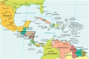
Which country on the map is Mexico?
1
2
3
4
4
Panama is a narrow country connecting 2 large land masses and is an example of:
a continent.
an isthmus.
a plateau.
a peninsula.
5
What three countries are a part of NAFTA (North American Free Trade Agreement)?
Canada, Mexico & Panama
Canada, United States & Mexico
Canada, United States & Great Britain
Mexico, Panama and Cuba
6
Tenochtitlan was the:
capital of the Aztecs
capital of the Mayans
capital of the Minions
capital of the Yucatan
7
This Spanish conquistador conquered the Aztecs in 1521.
Olmec
Tenochtitlan
Maya
Cortez
8
What was the purpose of building the Panama Canal?
Shortcut traveling from South America to North America
Shortcut for ships traveling from the Atlantic to the Indian
Shortcut for planes traveling from Atlantic to the Pacific
Shortcut for ships traveling from the Atlantic to Pacific
9
What value is most important in a limited government?
Loyalty to the leader
Regulation of the church
Government control
Freedom of the individual
10
The Panama Canal is in which country on the map?
4
8
7
6
11
GDP per Capita is the main indicator of:
a country's literacy rate.
a country's economic recession.
a country's economic level of development.
a country's government type.
12
Which number on the map is an isthmus?
8
10
1
5
13
A country with a low GDP per capita is a
Poorer Country
Richer Country
14
The colonization of Mexico had two long-lasting effects. They were _________ and ________.
English & French
Hinduism & Spanish
English & Roman Catholicism
Roman Catholicism & Spanish
15
The Panama Canal was built to make worldwide trade easier by making trade routes _____________.
longer
shorter
spicier
mixed
16
Which country has most farmers working on cooperatives owned and operated by the government?
Puerto Rico
Cuba
Panama
Mexico
17
Traditional Mexican homes are made of clay bricks called ______________.
straw
concrete
logs
adobe
18
Mexico City is the center of the government, has over 20 million people and is built on what?
Aztec ruins
Mayan ruins
an active volcano
American ruins
19
Central Mexico has a large population because of:
small villages & the Plateau of Mexico has a cooler climate
their religious beliefs.
the amount of rainfall.
major cities and the Plateau of Mexico has a cooler climate.
20
This waterway connects the Atlantic and Pacific Oceans.
Rio Grande
Carribean Sea
Isthmus
Panama Canal
21
A cooler climate made this area an attractive place to build cities.
The Panama Canal
The Plateau of Mexico
The Yucatan Penisula
The Isthmus of Panama
22
The Isthmus of Panama connects:
North and South trade routes.
the Aztecs to religous sites.
North and South America.
North and South Mexico
23
T/F: A
subsistence farmer
only grows enough food for what their families need to survive.
True
False
24
Cuba has what type of government?
Communist
subsistence
Democratic
limited
25
The Maya developed a calendar a form of writing with signs and symbols called _____________.
adobe
hieroglyphics
maize
isthmus
26
T/F: A communist dictatorship is an example of a limited government.
False
True
27
Cuba's government is communist and is ___________________ government.
a limited
a mixed
an unlimited
a free market
28
This group of Indians lived on the Yucatan Peninsula.
Toltec
Aztec
Mayan
Olmec
29
Hieroglyphics is:
writing using symbols to represent words.
words to represent symbols
the name of the Aztec's capital city.
the Mayan calendar.
30
On the map, number 10 is which country?
Panama
Haiti
Puerto Rico
Cuba